Featured post

Notice of Lake District Fees and Membership

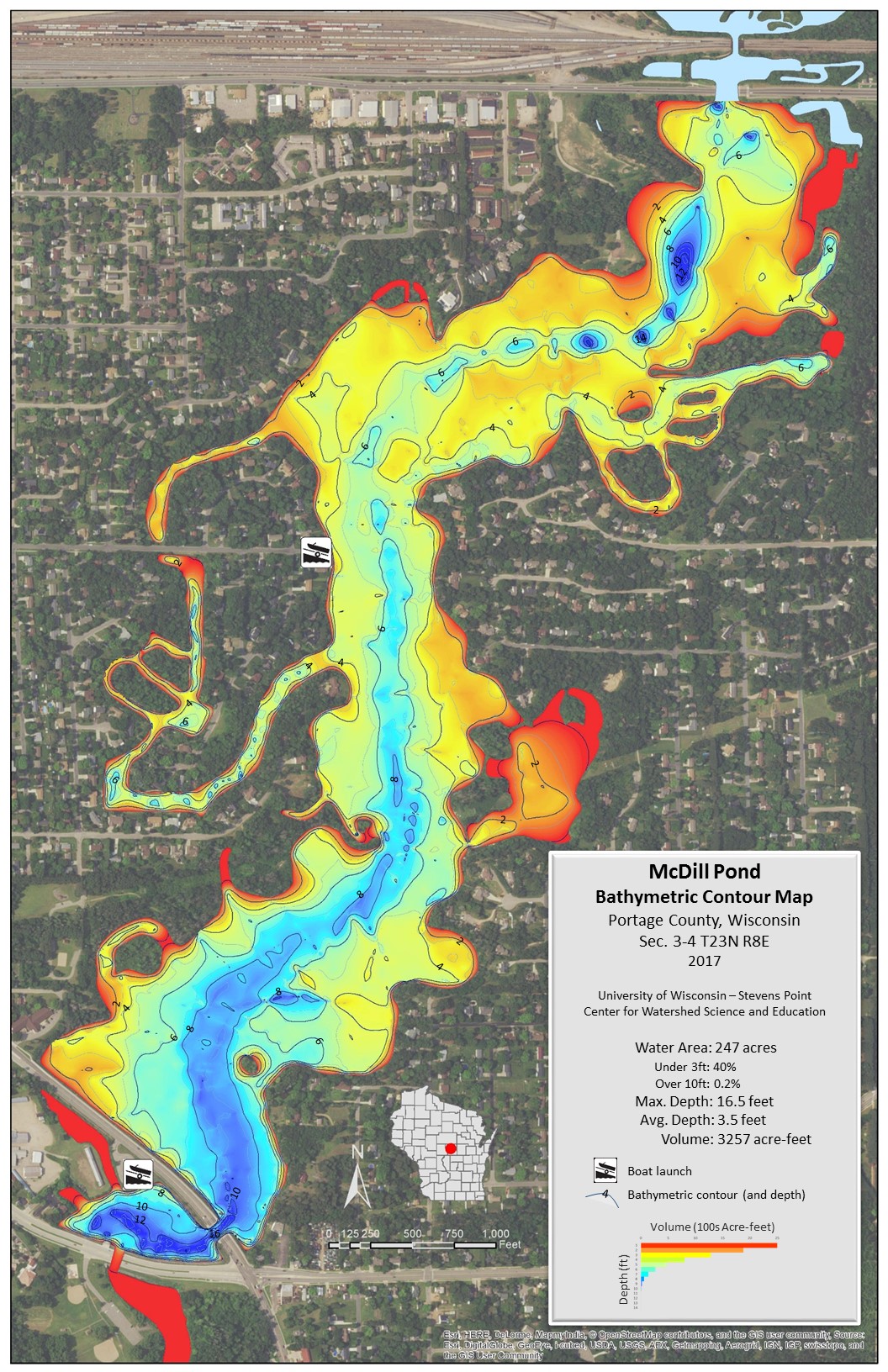
McDill Inland Lake Protection and Rehabilitation District under its bylaws of incorporation has the following criteria for membership: Membership in the Lake District shall be open to any individual, family, business, or organization, that (a) subscribes to the purposes of the Lake District and (b) owns or leases property within one mile of the lake for which the Lake District was incorporated. This includes all parcels that are waterfront and underwater in the McDill Pond 264 acre mapped area.

Lake District fees for 2024 are $400 per year per parcel. A special assessment was added in August 2021 of $5314.41 for the dredging project. Members of the lake district were allowed to pay up front the full amount of the dredging project assessment by 8/30/21, or be subject to split of the payment on the property tax bill over 15 years including interest. At year 5 the loan for the dredging project will be refinanced at going interest rate, adjusting the final pay off. Residents with an outstanding balance during year 5 will be allowed to pay off their remainder balance at that time, or have their yearly payment rate adjusted based on going loan rates.

All members within the lake district are billed on their tax bill for the year the lake district fees and if applicable to their property the special dredging assessment if they elected not to pay the full amount up front. The assessment for the dredging project started in 2023 tax bills. Lake district fees are considered a tax and are not optional under state statutes to the membership of the lake district. The lake district is not responsible for settling of real estate transactions in regards to the assessments which should be handled between buyer and seller. The lake district also has the right to include new property that falls into the lake district’s article of incorporation if land is subdivided or sold off from former government ownership.

Featured post

McDill Pond Spring 2024 Chemical Treatment Notice

The McDill Inland Lake and Rehabilitation District (the District) proposes to assess and manage up to 100 acres on McDill Pond to control the excessive growth of the exotic invasive aquatic plants Eurasian watermilfoil (EWM), its hybrid (HWM), and Curlyleaf Pondweed (CLP).

The District proposes to conduct applications of ProcellaCOR EC (florpyrauxifen-benzyl), Aquathol K (endothall), and/or Tribune (diquat) to be performed sometime between May and September, 2024 by TIGRIS Aquatic Services, LLC (TIGRIS), proceeding only after the District obtains a permit from the Wisconsin Department of Natural Resources. Notification of the exact dates of application(s) and water use restrictions associated with the use of ProcellaCOR EC will be provided by the posting of shoreline in and adjacent to treatment areas, and public access points.

There are no water use restrictions associated with use of ProcellaCOR EC, Aquathol K, and Tribune aside from an up to 5-day irrigation restriction. All other activities may go uninterrupted.

Additional details regarding the proposed management, including a copy of the permit application and the WDNR aquatic herbicide fact sheet on florpyrauxifen-benzyl, can be found at: www.mcdillpond.com.

If you do not have a computer and would like a copy of the permit or map you can request one by writing McDill Lake District 3317 Della St Stevens Point WI 54481. Please include a self addressed stamped envelope for mailing. 


Featured post

McDill Pond Plant Harvesting and Skimming maps

updated-harvest-map-122916 This is the updated revision completed by the Lake District and submitted to the Wisconsin DNR for use in 2017.  The harvesting map was updated to increase some areas on the southern half by the business 51 causeway, smooth out some corners for easier harvesting and connect one lane to another.  The skimming map will stay the same for 2017.  Skimming  is different than plant harvesting as it allows algae mats to be skimmed with the smaller harvester ONLY when the DNR is notified and approves 24 hours prior to skimming each time.  Please note the change in the cutting areas allowed vs previous years, as clear cutting is not allowed, and instead navigation channels will be cut.  Only 70% of the acreage of a waterbody may be harvested.


McDill Unsafe Ice Areas

The map is a compiled list of areas known to experience ice safety issues throughout the winter. Some areas are unsafe due to the river flow, others due to springs. Follow all DNR safety precautions when accessing the ice and keep monitoring for changing conditions. Ice depths vary throughout McDill during the winter, and no ice is safe ice, but the intent of the map is to help inform those accessing the ice where to avoid traveling.

McDill Pond Silt Trap Dredge Information

McDill Pond is undertaking a one million dollar dredging project to complete a 20 year dredge. The silt trap dredged in 2000 is now two thirds full, and to prevent further sedimentation in McDill the silt trap must be dredged. The purpose of the dredge is to solely preserve McDill Pond from further sedimentation and allow navigation so that the waterbody can be preserved for years to come. The construction of the detention basin has been completed at 4001 Patch St (McDill Disk Golf and Lake District Harvester Landing) and dredging will commence mid to late June. Michels Corp is the dredging contractor, Earth Inc is the construction/soil disposal contractor, and GEI Consulting is providing engineering services. The design of the dredging project with all the maps and depths, cross layers, etc can be found in the permit: WDNR IP Dredging Permit Application_DRAFT.

Common Questions:  What about the disk golf course?  The disk golf course was placed at the site of the 2000 dredging project sediment trap with the knowledge that McDill would need to dredge the sediment trap once every approximate 20 years. This means that once every 20 years the course must be shut down while dredging occurs. The detention basin that has been built will be filled in when completed and reseeded, and the area opened to the public again.

When will the project be completed? God only knows as Mother Earth is in control. Heavy rainy weather slows down work and makes it difficult for sand to dry out. Work disruptions due to illness or can’t get needed part in for repairs make it difficult to judge. We hope to see the project done completely by Spring 2023 and remediation of the work site finished.

How much is being removed?  PCI McDill Proposal 5.17.2021  See the 1 million dollar size project, and then cross reference to the link above on the design.

Can I go walking around there to see the operation?  No please stay out for your safety. Issues with trespassing will be turned in to local authorities per the contractors. Only associated project staff and McDill Harvesting staff are allowed in 4001 Patch St at this time.

Will boating be affected?  You betcha it will!  Once the crew starts up a large barge and water fenced off area will be present in different parts of McDill as different areas are dredged. Floating signs with reflectors will be in the area to warn people to stay out.  THIS IS FOR YOUR SAFETY!  While it may seem like it is a large area closed off for boating, its due to underwater pipes in the area.  Hit one of those and you won’t have a lower unit left on your motor, and you will be held responsible for the financial damage to the dredge equipment.

Who is paying for this?  All 170+ homeowners and only a small 67,000 grant from WI DNR.  Please support us via the donation box at the landings so that we can continue to make this project a success.

Do you think they will find <name item here> while dredging? Since this is a dredge of an area previously dredged multiple times, it is highly unlikely to find anything from before 2000 when the site was last dredged. Even in the new channel stretches being completed to Heffron St landing these areas were extensively dredged in 1960-63 when McDill was massively rebuilt by the local sportsmen club. Go see historic areal photos from before 1960 to post 1963 for the difference – three years of work put in to build modern McDill Pond. The 1 foot pipe that is being used is transporting a TON of material, so looking for things like watches, rings, etc is not something that can be done.

Residential Fertilizer Restriction Passed at Annual Meeting

McDill Inland Lake Protection and Rehabilitation District at its annual meeting passed a Resident Fertilizer Restriction that goes into effect immediately for its 176 residents. The general fertilizer restriction replaces the lake district’s former phosphate free fertilizer restriction since all fertilizers now sold in Wisconsin are phosphate free.  The restriction limits residents to twice a year fertilizing their yards, unless a soil test proves the need for additional fertilizing.  There is no limit on the amount of application of weed killers or other pesticides for nuisance control.   A water study conducted by the WI DNR over two years found high amounts of nitrogen entering McDill during the winter months from groundwater and spring runoff.  Due to the sandier soils around McDill, it is an important first step to control the amount of nitrogen entering McDill starting with the yards that have the greatest impact on McDill Pond.  The restriction is to be self regulating, and currently does not have any fines for violations of the restriction.  McDill Pond is also participating in efforts to promote healthy shorelands and work with local municipalities to address the high nitrogen levels entering McDill pond from various sources to mitigate the excess weed and algae growth in McDill Pond.      A copy of the restriction is below for reference.

Fertilization Restriction